REVIEW · OAHU
30 Minutes SHARED Helicopter Tour in Honolulu
Book on Viator →Operated by Honolulu Helicopter Tours · Bookable on Viator
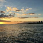
A helicopter over Honolulu can be a life-shortening shortcut. In just 30 minutes, you get a bird’s-eye sweep of Waikiki, Diamond Head, harbors, and memorial sites that you simply won’t see from the beach or streets.
I like the fact that it’s small: the max group size is three guests, so you’re not packed in with strangers. I also like the pilot angle—your pilot’s commentary helps you make sense of what you’re seeing, not just look at it.
One thing to consider: the price is steep for a short flight, and you’re also limited by the 300 lbs per passenger weight cap. Add in the fact that the tour requires good weather, and your schedule could need flexibility.
In This Review
- Key points before you go
- Why a shared 30-minute helicopter over Oahu is a smart use of time
- The real starting point: 1 Lagoon Dr and what’s waiting for you
- The route over Honolulu: harbors, beaches, and a Waikiki look from above
- Sand Island and Honolulu Harbor: the port view that explains the city
- Ala Moana Beach Park, Magic Island, and Ala Wai Harbor: the coastal geometry lesson
- Waikiki and Diamond Head: the postcard views with real orientation
- From Waialae Country Club to downtown Honolulu: seeing the city in layers
- Waialae Country Club: a quick look at East Honolulu’s quieter side
- Honolulu downtown and Aloha Tower Marketplace: where the city concentrates
- Punchbowl Crater and Moanalua Gardens: a more grounded view from overhead
- Punchbowl Crater: the National Memorial Cemetery of the Pacific from above
- Moanalua Gardens: a 24-acre pause in the middle of the city
- H-3 Highway and the viaducts: when the flight becomes engineering
- Black Point Sea pools and Aloha Stadium: the final photo push
- Pilot names you might hear, and how to get the best out of the commentary
- A quick tip for better photos
- Price and value: what $319 buys in a short, intense flight
- Weather and scheduling: how to keep your Hawaii plan from getting bent
- Should you book this 30-minute shared helicopter tour in Honolulu?
- FAQ
- How long is the 30-minute shared helicopter tour?
- What landmarks will we see during the flight?
- How many people are in the group?
- What’s included in the ticket?
- Is the tour dependent on weather?
- What’s the weight limit for passengers?
- What is the cancellation refund policy?
Key points before you go
- Small-group flight (max three guests) keeps the ride more personal and less chaotic
- Pilot commentary turns landmarks into something you can actually place on the map
- Photo-friendly route over Waikiki, Diamond Head, Punchbowl, and coastline areas
- Headsets included so you can hear the pilot clearly in the cockpit
- Good-weather requirement means you’ll want a backup plan for your day
Why a shared 30-minute helicopter over Oahu is a smart use of time

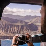
If you’re short on time in Honolulu, a 30-minute helicopter tour is one of the most efficient ways to see a wide area. You trade beach-sun planning for fast aerial context: you rise above Waikiki, then you start stacking landmarks in your head like puzzle pieces.
The shared part matters, too. With a max of three guests, it still feels like a more intimate experience than the big cattle-call flights you might imagine. That also tends to make the pilot’s commentary easier to follow, since you’re not listening over a roar of competing voices in a jammed cabin.
The vibe is also practical: this isn’t a long tour where you might get bored halfway. Thirty minutes is just enough to feel you got your money’s worth on views—without being stuck in the air all afternoon.
You can also read our reviews of more tours and experiences in Oahu


The real starting point: 1 Lagoon Dr and what’s waiting for you

You’ll meet at 1 Lagoon Dr, Honolulu, HI 96819, and the experience ends back at the meeting point. It’s close to public transportation, so you’re not forced into a full car-and-parking ordeal if you’re already using transit in the area.
On the prep side, you get an aviation headset (so you can actually hear the pilot) and a cell phone lanyard. That lanyard sounds small, but it helps keep your phone under control while you’re moving around and preparing for the flight.
It’s also offered in English, so you won’t be stuck guessing what the pilot is explaining. Confirmation is sent at booking, and you’ll use a mobile ticket, which is handy if you don’t want to scramble for paper.
The route over Honolulu: harbors, beaches, and a Waikiki look from above
The flight starts and ends at HNL, then you’ll work your way around the island’s most recognizable Honolulu coastlines.
Sand Island and Honolulu Harbor: the port view that explains the city
Right after takeoff, you’ll get aerial views of Sand Island and then shift to Honolulu Harbor (also known by names like Kulolia and Ke Awa O Kou). Since it’s the principal seaport of Honolulu and the State of Hawaiʻi, it’s the kind of landmark you can’t fully appreciate from the sidewalk.
From above, the harbor’s layout becomes obvious. You start to see how Waikiki, downtown, and the waterfront connect, and why so much of Honolulu’s energy funnels through this area.
Ala Moana Beach Park, Magic Island, and Ala Wai Harbor: the coastal geometry lesson
Next up is Ala Moana Beach Park, described as a free public park between Waikiki and downtown. It’s 100 acres, and it includes a wide gold-sand beach that’s over a half-mile long. From the air, that length reads clearly, and you can see the park’s place along the shoreline rather than treating it like a single spot.
Then you’ll see Magic Island, a small man-made peninsula adjacent to Ala Moana Beach Park and the Ala Wai Yacht Harbor. Even without any ground walking, the aerial view helps you understand the island-within-the-island feel created by the shape of the peninsula.
You’ll also pass over Ala Wai Harbor, noted as the largest small boat and yacht harbor in Hawaii. The key value here is location: the harbor sits between Waikiki and downtown, with Magic Island on one side and the Honolulu waterfront on the other. From the cockpit, it becomes a clear boundary line between neighborhoods.


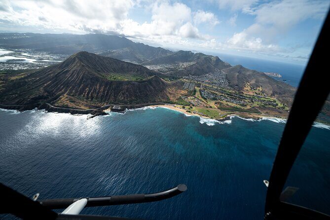
Waikiki and Diamond Head: the postcard views with real orientation
You’ll fly over Waikiki, and the description you’ll hear is the one you can picture quickly: high-rise hotels line the shore, it’s known for a surf beach, and Kalakaua Avenue has designer fashion stores. The area also has a after-dark rhythm with waterside cocktail bars and fine dining, plus Kuhio Beach hula shows.
Then comes Diamond Head, a volcanic tuff cone known to Hawaiians as Lēʻahi. The Hawaiian name relates to lae plus ʻahi, and it’s tied to the shape of the ridgeline. From the air, that shape becomes easier to spot than from one distant viewpoint.
If you care about photography, this is where you’ll likely appreciate the timing. These are big landmarks with strong visual edges, so even short windows can produce photos that look like you planned the shot.
From Waialae Country Club to downtown Honolulu: seeing the city in layers
After the iconic coast, you’ll get more variety as the route moves inland and toward downtown.
Waialae Country Club: a quick look at East Honolulu’s quieter side
You’ll see Waialae Country Club, described as a private club founded in 1927 and designed by Seth Raynor. The course is a par 72 at 7,125 yards from the Championship tees, and you’ll also hear about the Members tees distance and ratings.
Even if you don’t play golf, it’s still a meaningful aerial change-up. It’s a reminder that Honolulu isn’t just beach and skyline—it has established, land-based institutions that show up in the patchwork from above.
Honolulu downtown and Aloha Tower Marketplace: where the city concentrates
You’ll also see Honolulu Downtown, Hawaii’s political and business hub, with skyscrapers and Iolani Palace. The description you get connects local landmarks with how downtown works as a center, not just a cluster of buildings.
On the waterfront, you’ll see Aloha Tower Marketplace, anchored by the 1920s Aloha Tower and framed by sea views, a waterfront stage, and waterfront restaurants. From the air, the tower and harbor setting show why it’s such a natural focal point.
Punchbowl Crater and Moanalua Gardens: a more grounded view from overhead
Helicopter routes often focus on the fun stuff. Here, you also get a solemn stop that makes the flight feel more complete.
Punchbowl Crater: the National Memorial Cemetery of the Pacific from above
You’ll fly over the National Memorial Cemetery of the Pacific at Punchbowl Crater. It’s a memorial cemetery for U.S. Armed Forces members and those who gave their lives.
From above, it’s a reminder that landmarks can be more than scenery. If you’re the type who likes to understand the place you’re seeing, this part adds weight. It can also help your brain switch from “wow views” to “context,” which makes the whole trip feel more worth it.
Moanalua Gardens: a 24-acre pause in the middle of the city
You’ll also see Moanalua Gardens, described as a privately owned public park that covers 24 acres. The park is tied to King Kamehameha V through the Kamehameha V Cottage and Prince Lot Kapuāiwa.
You’ll also get references to the annual Prince Lot Hula Festival and a notable monkeypod tree known in Japan as the Hitachi tree. From the air, the garden feel lands differently than it would on foot: you see the scale of the green space and how it interrupts the harder edges of surrounding roads.
It’s the kind of aerial contrast that helps you remember the flight as more than just Waikiki.
H-3 Highway and the viaducts: when the flight becomes engineering
This is where the helicopter changes from sightseeing to pattern recognition.
You’ll see Interstate H-3 (also known as the John A. Burns Freeway). The route crosses the Koʻolau Range along several viaducts and through the Tetsuo Harano Tunnels, plus the Hospital Rock Tunnels. Even if you don’t love highways, aerial views make the route’s path through terrain easy to grasp.
You’ll also see details tied to the interchange area—part of the Moanalua Freeway between Route 99 (Kamehameha Highway) and the western H-1 interchange remains designated as Route 78.
Why this is valuable: from the ground, roads are just roads. From above, you can actually track how the island’s infrastructure threads through the landscape.
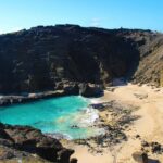
Black Point Sea pools and Aloha Stadium: the final photo push
Near the end of the route, you’ll pass over Black Point Sea pools. The key benefit here is simple: from a helicopter, coastal rock-and-water areas become easier to read and photograph than from street level.
Then you’ll see Aloha Stadium, described as a closed multi-purpose stadium in Halawa, and noted as the largest stadium in Hawaii. As of December 2020, it ceased fan-attended operations indefinitely and placed a moratorium on scheduling new events.
That detail matters in a subtle way. When you see a big structure like this from the air, it’s easier to understand how massive it is, and the current context makes it feel less like generic skyline and more like a specific place with a story tied to how it’s being used.
Pilot names you might hear, and how to get the best out of the commentary
One of the strongest parts of this style of tour is the human factor: the pilot tends to be engaged, friendly, and ready to explain what you’re seeing.
In past flights with this operator, pilots have included people like Scott and Stefan, and support has included Jacob as well. The common thread is communication—your pilot gives context while you’re in the air, which helps you spot landmarks faster and know what they are without needing to guess.
A quick tip for better photos
If you’re offered a doors-off option on your departure, it’s worth asking about. One flight experience shared that doors off made photos more satisfying. Even if your hands are inside the headset zone (safety first), it often means clearer angles.
Also, keep your expectations realistic for a shared flight. You’ll get a sequence of landmarks, not an hour-long crawl over just one spot. That means you should be ready to shoot quickly when the plane lines up.
Price and value: what $319 buys in a short, intense flight
At $319 per person for about 30 minutes, this is not a budget activity. But value here isn’t only the flight time—it’s the access to viewpoints.
You’re paying for:
- a short window where you cover a wide spread of Honolulu without driving
- a small group size that keeps the cabin calmer
- onboard context from a pilot, not just scenery
If you’re traveling as a couple or a small group, the shared format can also feel like a better deal than full private charters, because you’re not paying for empty seats. And since the flight is built around recognizable landmarks—harbors, Waikiki, Diamond Head, Punchbowl, and Moanalua—the “I can’t believe I saw that from up here” feeling is more likely to hit.
Booking timing can also affect your choices. On average, this tour is booked around 32 days in advance, so if you have firm dates, earlier planning usually keeps options open.
Weather and scheduling: how to keep your Hawaii plan from getting bent
Helicopter rides are at the mercy of conditions. This one requires good weather, and if it’s canceled due to poor weather, you’ll be offered a different date or a full refund.
My practical advice: don’t schedule this as the only thing you can’t move. If you’re building an itinerary, give yourself at least one other option on either side of your target day—then a reschedule doesn’t wreck your whole trip.
Also remember the tour is about views. If visibility is limited, you might still go, but your best photos will depend on the day’s clarity.
Should you book this 30-minute shared helicopter tour in Honolulu?
Book it if you want a fast, high-impact aerial overview of Honolulu without spending your day driving. The combination of small group size (max three guests), pilot commentary, and the mix of landmarks—from harbors and Waikiki to Diamond Head and Punchbowl—is exactly how you make a short helicopter flight feel like more than a thrill.
Skip it (or think twice) if you’re on a tight budget, you need a very fixed schedule, or you’re near the weight limit. And if you’re the type who prefers slow travel—long beach time, lots of walking, and street-level details—this will be a different kind of Hawaii experience.
If you want the best match: do it for the “only in the air” perspective, and schedule it for a day when you can be flexible.
FAQ
How long is the 30-minute shared helicopter tour?
The flight is 30 minutes (approx.) and it starts and ends at HNL, returning back to the meeting point.
What landmarks will we see during the flight?
You’ll get views from above of places including Sand Island, Honolulu Harbor, Ala Moana Beach Park, Magic Island, Ala Wai Harbor, Waikiki, Diamond Head, Waialae Golf Course, Honolulu Downtown, Punch Bowl Cemetery, Moanalua Gardens, H-3 Highway, and Aloha Stadium, plus areas like Black Point Sea pools and the H201 interchange.
How many people are in the group?
This experience has a maximum of three travelers.
What’s included in the ticket?
You get an aviation headset and a cell phone lanyard.
Is the tour dependent on weather?
Yes. The tour requires good weather. If it’s canceled due to poor weather, you’ll be offered a different date or a full refund.
What’s the weight limit for passengers?
The total weight per passenger is listed at 300 lbs.
What is the cancellation refund policy?
You can cancel for a full refund if you cancel up to 24 hours in advance. If you cancel less than 24 hours before the experience’s start time, the amount you paid will not be refunded.