REVIEW · OAHU
60 Minutes SHARED Helicopter Tour in Honolulu
Book on Viator →Operated by Honolulu Helicopter Tours · Bookable on Viator
A 60-minute helicopter tour is a shortcut. You trade long drives for a fast aerial scan of Oahu’s most famous coastlines, bays, and landmarks. This shared flight out of Honolulu focuses on big views with a pilot who talks just enough to keep you looking outside.
What I like most is how quickly you can orient yourself. In an hour you get a sense of where Waikiki sits next to Diamond Head, how harbors and beaches line up, and how Pearl Harbor and the shoreline feel from above. I also like the small size for a shared tour, with a maximum of 3 travelers, so it feels less crowded than the bigger group options.
The main consideration is the weather. This experience requires good weather, so if conditions are off, they’ll change the date or refund you. Also, at $449 per person, it’s not a casual add-on. It’s a splurge you want to plan for.
In This Review
- Quick hits
- Why this 60-minute flight works so well on Oahu
- Start at 1 Lagoon Dr: the easy Honolulu meet-up point
- Cabin details that affect comfort: 300-lb limit and small-group feel
- The Waikiki and Diamond Head flyover: harbors, beaches, and the city edge
- Oahu from above: Hanauma Bay, blowhole views, and Makapu’u landmarks
- Pali Lookout and Kaneohe Bay: the cliffs and the highway feel
- North Shore glimpses: Turtle Bay to Waimea Bay and Haleiwa town
- Central Oahu and the Dole area: recognizing the island’s inland pockets
- Pearl Harbor in the air: USS Arizona Memorial and the shipyard zone
- The pilot experience: commentary that doesn’t drown the view
- Price and value: what $449 buys you (and what it doesn’t)
- Weather, timing, and safety: the realistic part of planning
- Who this tour is best for
- Should you book this 60-minute helicopter tour?
- FAQ
- How long is the helicopter tour?
- What does the tour cost?
- Where do I meet for the tour?
- Is the tour offered in English?
- What’s included with the tour?
- What’s the maximum group size and weight limit?
- What happens if weather is poor?
Quick hits
- Max 3 travelers in the shared cabin: less bustle, more personal feel
- A route built for one-hour orientation: harbors, Waikiki, Diamond Head, east side, and Pearl Harbor
- English commentary from the pilot: enough context to make the geography click
- Cell phone lanyard included: easier to film one-handed while you’re focused on the window views
- Professional, safety-first vibe: pilots manage smooth running even if equipment needs attention
Why this 60-minute flight works so well on Oahu

Oahu is a lot to wrap your head around. The island can feel like it’s all beaches, then suddenly you’re in city roads, then back to cliffs and coves. This helicopter tour helps you understand the shape of the place fast.
You’re not buying time for sitting in traffic or searching for the best viewpoint. You’re buying a high-speed, overhead tour that makes famous spots easier to place later when you drive around. If you’ve only got a day or two, this is one of the most efficient ways to get the big picture.
And because it’s a shared flight with a small cap of up to 3 travelers, the experience doesn’t feel like a cattle-call. You’ll likely spend more time looking out and less time waiting for the group to settle.
You can also read our reviews of more tours and experiences in Oahu


Start at 1 Lagoon Dr: the easy Honolulu meet-up point
The tour starts and ends back at 1 Lagoon Dr, Honolulu, HI 96819. That matters because you can plan your day around a central hub instead of trekking across town.
The meeting spot is also described as near public transportation, which is useful if you’re trying to reduce car time. If you’re arriving by rideshare, this kind of location usually means straightforward pickup and drop-off.
Plan to arrive a bit early. Even when everything runs smoothly, you’ll want a few minutes to get oriented, find the right place, and settle in so you can start enjoying the view as soon as you’re airborne.
Cabin details that affect comfort: 300-lb limit and small-group feel

This helicopter experience is listed with a total weight per passenger of 300 lbs. If you’re near that limit, double-check before you book so you don’t end up scrambling.
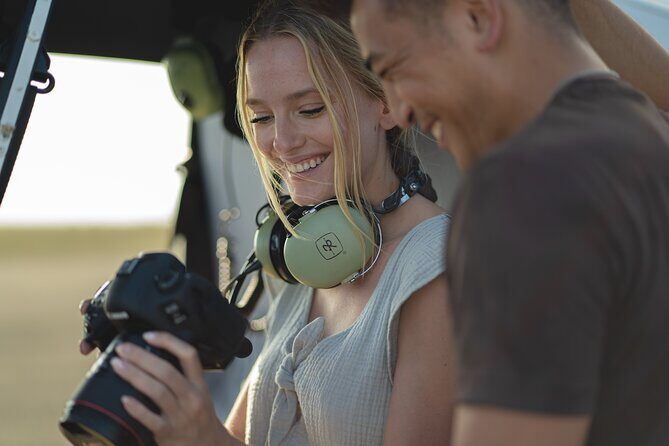
You’ll also want to know the group size: maximum of 3 travelers. That small number is a real comfort factor. It generally means less crowding, fewer interruptions, and more room to keep your attention where it belongs—on the scenery.
They include a cell phone lanyard, which sounds small, but it’s practical. From a helicopter, you often want to film, then glance back up at the view again. Having a lanyard helps keep your phone secure so you can focus on the visuals without constant grip-tension.
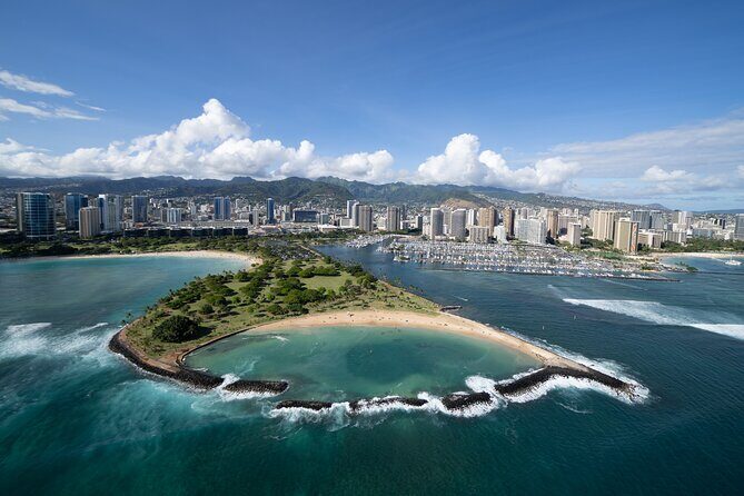
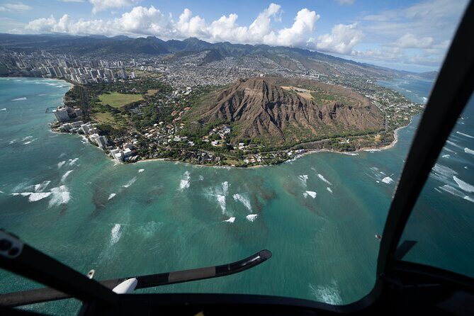
The Waikiki and Diamond Head flyover: harbors, beaches, and the city edge
The flight segment around Stop 2 and Stop 3 is where Oahu starts to make sense fast. You get Waikiki, then you sweep toward Diamond Head, and you see the coastline with the harbors and beaches as connected pieces instead of separate stops on a map.
Here’s what that usually clarifies for you:
- Waikiki and the beach strip: you can see how tightly the shoreline wraps around hotels and neighborhoods.
- Honolulu Harbor and nearby water: the shape of port areas becomes obvious, not guessed.
- Ala Moana Beach Park and Magic Island: these show up as defined shoreline segments rather than names you’ve only read about.
From above, Diamond Head isn’t just a viewpoint. It becomes a landmark that helps you understand wind exposure, the steepness of the terrain, and why certain beaches look sheltered while others look open.
You’ll also likely spot the smaller “in-between” landmarks that most land tours can’t show in one pass. Items like Ala Wai Harbor and the area around the golf courses can help you connect routes later if you do self-guided driving.
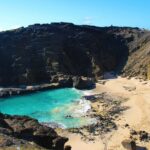
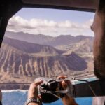
Oahu from above: Hanauma Bay, blowhole views, and Makapu’u landmarks

Next comes the island’s side that feels more dramatic and natural. You’ll get Hanauma Bay Nature Preserve, then you continue toward Makapu’u Point Tide Pools and the surrounding lookouts.
Even if you’ve seen photos of Hanauma Bay, the aerial angle is different. From above, you can better judge:
- the curve of the bay,
- how it sits relative to the coastline,
- and how water color changes with exposure.
This part of the route also references a few iconic features that tend to get attention on the ground, like a famous blow hole area and nearby sandy spots. From a helicopter, you’re not watching waves from the same distance, but you do get a strong sense of where the dramatic rock formations line up along the shore.
As you approach the Makapuu lighthouse area and Pele’s chair, the coastline starts to show the kind of cliff-and-cove rhythm that makes Oahu feel like more than a single long beach strip. You’ll also see smaller offshore shapes mentioned in the route plan, like Rabbit Island and China Man’s Hat / Chinaman’s Hat type features that make the horizon look like it has punctuation marks.
You can also read our reviews of more tours and experiences in Oahu


Pali Lookout and Kaneohe Bay: the cliffs and the highway feel
The itinerary includes Pali Lookout, Marine Corps Base Hawaii, and Kaneohe Bay. From the air, these don’t just appear as dots—they connect into a story about elevation and geography.
Why this segment matters: you’ll see how the island rises inland and how the coast changes as the terrain shifts. The route also calls out key highway reference points like the H3 Highway and a major interchange (H201 Interchange). Even if you don’t plan to drive those roads, you’ll leave knowing where the main corridors run.
Over Kaneohe Bay, the water can read very differently from Waikiki. You often get a clearer sense of sheltered vs. exposed coastline. That helps later when you decide where to swim, where to walk, and which beaches might feel calmer.
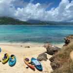
North Shore glimpses: Turtle Bay to Waimea Bay and Haleiwa town
This helicopter route includes names associated with North Shore scenery: Turtle Bay, Sunset Beach, Bonsai Pipeline, Waimea Bay, and Haleiwa Town. In one hour you don’t get a slow, on-foot North Shore experience. You get a fast aerial scan.
But that aerial scan is useful. North Shore is not just one vibe—it’s a series of coast segments with different looks and levels of exposure. From above, you can see how:
- the shoreline opens up,
- breaks in the land create headlands and viewpoints,
- and the coastline changes as you move along the windward side.
If you’re the type who likes to later return and choose one beach area carefully, this segment can do the heavy lifting for you. You’ll come away with a short list of what looks most appealing from the air.
Central Oahu and the Dole area: recognizing the island’s inland pockets
The itinerary also includes Oahu Central Valley and the Dole Pineapple Plantation area, including the Dole Maze. Helicopter tours aren’t always best for inland details, but you still get a sense of where agriculture sits relative to coast.
From above, you often see the contrast right away: developed coastline vs. inland areas that look more structured and grid-like. The Dole area shows up as a complex of lots and paths, and you can mentally connect it to the drive routes you might take later.
If you’re doing the Dole stop as a family-friendly add-on, a quick aerial understanding makes it easier to connect the dots when you’re standing on the ground.
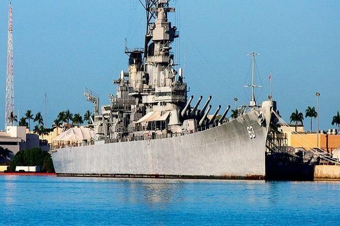
Pearl Harbor in the air: USS Arizona Memorial and the shipyard zone

One of the biggest reasons people book a Honolulu-area helicopter flight is the chance to view Pearl Harbor Memorial and the USS Arizona Memorial zone from above. This route specifically references those sites, plus additional naval names like the USS Missouri and other retired ships.
From the helicopter, you’re not touring the museum exhibits. You’re seeing the layout: water channels, shore boundaries, and how the memorial complex sits in the harbor environment. That kind of aerial context can make a later land visit feel more connected, like you’re matching what you see on the ground to what you already understood from the air.
You also get references to other ship-related landmarks in the route plan, like the USS Utah. Even if your eyes catch it for only a moment, it helps you understand this isn’t just one point. It’s a whole harbor region with multiple historical anchors.
And yes, it’s emotional for many people. The aerial view can feel unusually stark because the scene is so clear-cut: water, land, and the memorial zone.
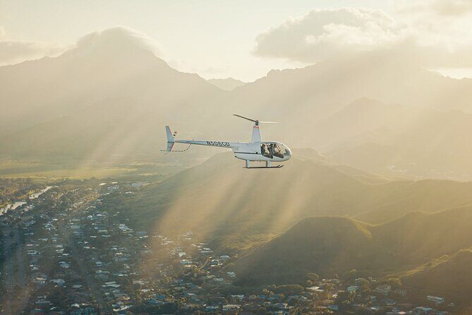
The pilot experience: commentary that doesn’t drown the view
In a one-hour flight, the pilot style matters. You want just enough narration to make the names and shapes click. You don’t want a lecture that forces you to look away.
I like that this tour is designed with English commentary, and I’ve seen pilots tailor their talk so you still have plenty of time to look. In one flight experience, Stefan was mentioned as giving just enough commentary for reflection time, with a strong emphasis on safety and customer care.
Another highlight: Jim was cited for being informative, and even when a communication issue forced a quick change (including a return to the heliport for headset adjustment), the ride still delivered the full 60 minutes of wonder. That’s the kind of operational flexibility you want to hear about, even secondhand—because it hints that the company manages issues without cutting the core experience short.
Price and value: what $449 buys you (and what it doesn’t)
$449 per person for about an hour is serious money. But you should judge value by what this tour replaces.
What you’re paying for:
- a time-efficient overview of Oahu’s best-known and hardest-to-access scenery,
- an angle you can’t replicate from typical viewpoints without serious effort,
- and a small shared cabin size (max 3) that can make it feel more personal.
What you’re not getting:
- a hands-on, stop-and-stroll experience,
- a slow itinerary where you spend long minutes on each location.
So this is best if your priorities are visuals, orientation, and wow-per-hour. If your goal is history deep-dives, you’ll still want to pair this with land time at places like Pearl Harbor sites. The helicopter is the setup act. The ground stops are the full performance.
A small practical note: it’s listed as commonly booked about 29 days in advance on average. If you’re traveling during peak weeks, earlier planning usually helps you get a seat on a time slot that matches your schedule and weather expectations.
Weather, timing, and safety: the realistic part of planning
This experience requires good weather. If it’s canceled due to poor conditions, you’re offered a different date or a full refund. That’s the right approach for helicopter flying because visibility and wind affect safety.
Because of that, I treat this tour like a weather-dependent anchor. If you can, schedule it with breathing room so you’re not stuck with only one possible day.
On safety, the tone from the experience you shared reads as calm and professional—pilots running the flight confidently and keeping passengers reassured. For a first-time flyer, that kind of calm matters more than any marketing line.
Who this tour is best for
This works especially well if:
- you’re short on time and want a quick grasp of Oahu,
- you want a bucket-list aerial view without a full day commitment,
- you like learning the lay of the land so your later sightseeing feels more targeted.
It also suits couples and older travelers who may not want to hop between multiple viewpoints. The smaller group size (max 3) helps, and the tour structure is built around seeing a lot without walking.
If you’re traveling with kids, you’ll probably find it depends on your child’s comfort with heights and enclosed seating—nothing in the data says it’s specifically child-focused. But the short duration is on your side.
Should you book this 60-minute helicopter tour?
If you can afford it, I think you should seriously consider booking, because it hits the sweet spot of scope vs. time. You get Waikiki and Diamond Head, you sweep through east-side scenery around Hanauma Bay and Makapu’u, you catch North Shore names, and you include the Pearl Harbor memorial area from above. That’s a lot of “aha” per hour.
I’d only hold back if:
- you’re unlikely to be able to flex your schedule if weather cancels,
- or you’d rather spend that money on more hours on the ground.
One more decision-maker: look closely at the weight limit of 300 lbs and make sure your planning fits that. If it does, this is one of those experiences where the first few minutes make you understand why people recommend it so strongly.
FAQ
How long is the helicopter tour?
It’s listed as about 1 hour (approx.).
What does the tour cost?
The price is $449.00 per person.
Where do I meet for the tour?
You meet at 1 Lagoon Dr, Honolulu, HI 96819, USA, and the tour ends back at the meeting point.
Is the tour offered in English?
Yes, it’s offered in English.
What’s included with the tour?
A cell phone lanyard is included.
What’s the maximum group size and weight limit?
The tour has a maximum of 3 travelers, and the listed total weight per passenger is 300 lbs.
What happens if weather is poor?
This experience requires good weather. If it’s canceled due to poor weather, you’ll be offered a different date or a full refund.