REVIEW · OAHU
30 Minutes PRIVATE Helicopter Tour in Honolulu
Book on Viator →Operated by Honolulu Helicopter Tours · Bookable on Viator
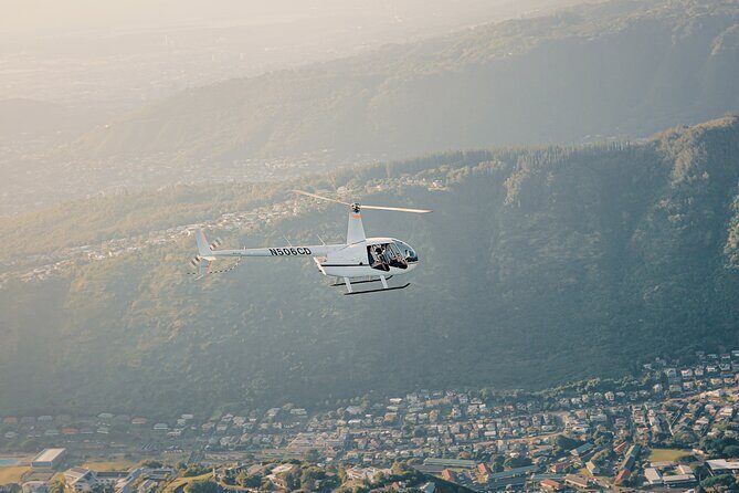
Honolulu looks different from up high. This 30-minute private helicopter ride lets you scan Waikiki, Diamond Head, and Honolulu’s coastline fast, with your pilot calling out key sights from the air. I like the small, private-group setup that keeps the experience focused, and I like that you get a clear, efficient loop without wasting time on extra activities. The main thing to consider is weather: the tour needs good conditions, and poor weather can mean a date change or a full refund.
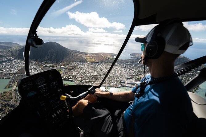
I also like the practical touchpoints that make the flight feel easy. The tour includes aviation headsets so you can hear your pilot, plus a provided cell phone lanyard to keep your phone secure while you frame shots. One review highlights the professionalism and safety of the experience with pilot Stefan, which is exactly the vibe you want when you’re paying for a helicopter.
In This Review
- Key highlights I’d focus on
- A tight 30 minutes over Honolulu: how to make it worth $359
- Private helicopter tour logistics: meeting at 1 Lagoon Dr and keeping it simple
- The included gear that actually helps: headset + cell phone lanyard
- Weight limit: the one body-spec detail you should take seriously
- The route overview: a quick hit list of Honolulu from above
- Start at HNL: the best first minutes for orientation
- Waikiki and Diamond Head from above: the coastline picture you can’t fake
- Ala Moana Beach Park, Magic Island, and the harbor system
- Honolulu Downtown, Punch Bowl Cemetery, and the road geometry (H201 + H3)
- Waialae Golf Course, Moanalua Gardens, and Black Point Sea pools
- Aloha Stadium: the recognizable finish that helps you remember the loop
- Safety and pilot quality: why the name Stefan gets mentioned
- Value check: is this tour worth the cost?
- Weather and timing: the only real variable you can’t control
- Who should book this 30-minute private flight
- Should you book Honolulu Helicopter Tours for this private flight?
- FAQ
- How long is the helicopter ride?
- Is this a private tour?
- What is the price per person?
- Where do we meet for the tour?
- Where does the tour end?
- What’s included in the tour?
- Do you provide a mobile ticket?
- Is there a weight limit?
- What if the weather is poor?
- How far in advance should I book?
Key highlights I’d focus on
- Private group flight over Honolulu, so you’re not sharing the experience with strangers
- 30 minutes in the air with a route that hits coastal icons and downtown landmarks
- Headsets included to help you actually understand what you’re seeing
- Phone lanyard included so you can use your camera without worrying about dropping your device
- Easy meeting point at 1 Lagoon Dr, Honolulu
- Pilot-led sightseeing as you pass major beaches, harbors, and points of interest
A tight 30 minutes over Honolulu: how to make it worth $359
At $359 per person, this isn’t the cheapest way to see Oahu. The value here is time plus attention: you’re buying a private, pilot-guided aerial tour where the main event is simply getting overhead. You don’t need to schedule a bunch of stops, line up for viewpoints, or fight traffic to get the big-picture view.
That 30-minute duration (with about 30 minutes of flight time) matters. It’s long enough to get a real sense of Honolulu’s layout—coastline, harbors, and the way neighborhoods stack up around key landmarks. It’s short enough that you should go in knowing you’re catching the highlights rather than doing a full-day island cruise from the sky.
The tour also earns strong confidence from its track record. A perfect overall rating (5 out of 5) and a recommendation rate of 100% suggest that people consistently feel they got what they paid for—especially around safety and smooth operations. If you’re the type who hates overlong tours and wants a clean, focused experience, this format fits.
You can also read our reviews of more private tours in Oahu


Private helicopter tour logistics: meeting at 1 Lagoon Dr and keeping it simple
This tour starts and ends back at the same spot: 1 Lagoon Dr, Honolulu, HI 96819. That round-trip “back where you started” structure is underrated. It removes one annoying variable, since you’re not trying to solve transport or end somewhere inconvenient.
The departure point is described as easy to find, and it’s near public transportation. That’s helpful if you’re staying nearby and don’t want to overspend on ride-hailing just to get to the pickup.
You’ll also get a confirmation at the time of booking, and the tour uses a mobile ticket. That’s convenient—just have your phone ready at the meeting point.
The included gear that actually helps: headset + cell phone lanyard
Two small inclusions make a noticeable difference during a helicopter flight:
- Aviation headsets are provided, which helps you hear your pilot’s directions and descriptions. If you like learning what you’re seeing rather than just snapping photos, this matters.
- A cell phone lanyard is included, which sounds basic until you’re holding your phone while looking out over water and coast. It’s a practical safety and usability boost.
These details don’t add drama. They just reduce friction. And with a ride that’s only 30 minutes long, minimizing friction is part of maximizing your experience.
Weight limit: the one body-spec detail you should take seriously
There’s a clear total weight limit per passenger: 300 lbs. That’s not something to treat casually. If you’re near the limit, it’s worth planning carefully and booking with confidence that everyone in your party meets the requirement.
If anyone in your group is above the limit, you may want to rethink options before you get attached to the idea of the flight.
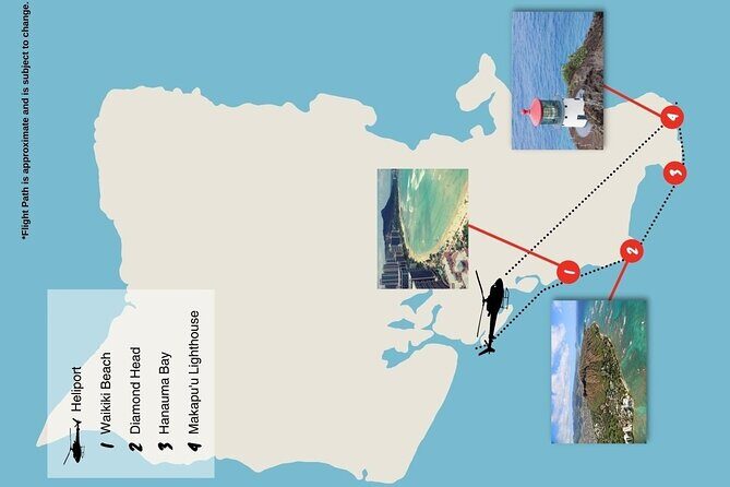
The route overview: a quick hit list of Honolulu from above
Your pilot doesn’t just fly you over the city. You’ll get a guided view of famous landmarks as you pass them overhead, including valleys, waterfalls, and mountains as part of what the pilot points out during the flight.
The sightseeing list includes a lot of the places people already recognize, which is great for first-timers:
- Sand Island
- Honolulu Harbor
- Ala Moana Beach Park
- Magic Island
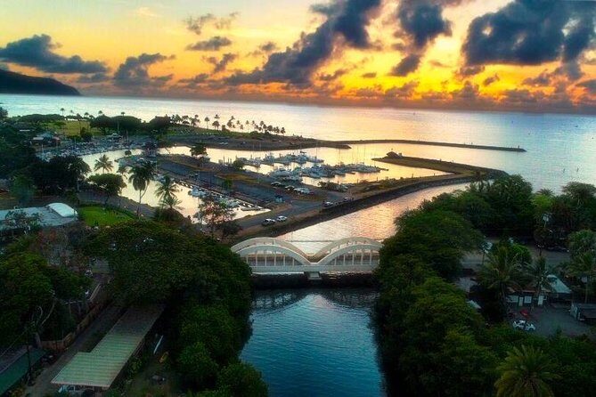
- Ala Wai Harbor
- Waikiki
- Diamond Head
- Waialae Golf Course
- Honolulu Downtown
- Punch Bowl Cemetery
- H201 Interchange
- Black Point Sea pools
- Moanalua Gardens
- H3 Highway
- Aloha Stadium
And you start and stop at HNL (Daniel K. Inouye International Airport), with the tour ending back at the meeting point.
A note on how to interpret this list: from the air, names become coordinates. Harbors read like shapes and lanes. Beaches read like color bands. Roads and interchanges become patterns. This route is built to help you understand Honolulu’s geography quickly.
You can also read our reviews of more tours and experiences in Oahu

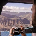


Start at HNL: the best first minutes for orientation
You begin and end at HNL, so the early part of the flight gives you an instant sense of orientation. Airports also tend to frame the start of a route well: you get a clean “before/after” moment where the city goes from a patchwork of blocks into a coastline map.
From the sky, you’ll likely notice how Honolulu bends around the water rather than spreading evenly inland. That’s the kind of big-picture view that’s hard to replicate on the ground in a short time.
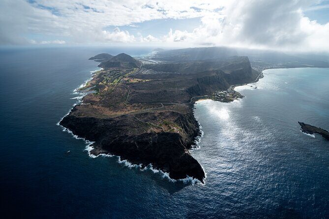
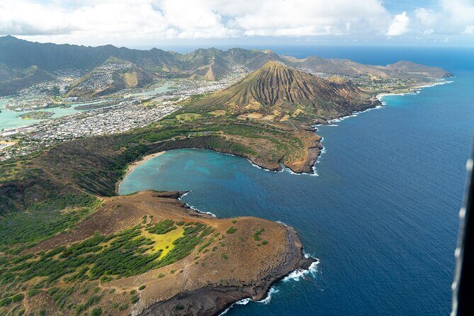
Waikiki and Diamond Head from above: the coastline picture you can’t fake
If you care about Honolulu’s most famous postcard area, this is a strong stop set. As you fly over Waikiki, you’ll also see Diamond Head nearby, which helps you connect the neighborhood to the shape of the coastline.
Aerial views are best at showing relationships: how the beach strip lines up with the harbors, how the sea creates natural boundaries, and how Diamond Head sits like a landmark at the edge of everything else. Even if you’ve seen Waikiki plenty on photos, the aerial angle tends to make it feel more real—like you’re finally seeing the whole place as one plan.
This is also where headsets help. If your pilot is pointing things out as you go, this part of the flight becomes more than just looking.
Ala Moana Beach Park, Magic Island, and the harbor system
The route includes Ala Moana Beach Park and Magic Island, plus Ala Wai Harbor and Honolulu Harbor. That’s a smart combo because it gives you the harbor-and-beach rhythm of the south shore.
From above, you can often see how water features break the city into sections. The harbors stand out as organized basins, while nearby beach areas read as smoother curves along the edge. It’s the kind of view that helps you understand why the city feels so built around the ocean rather than next to it.
If you’re the type who likes visual order, this portion is rewarding. If you just want the most famous scenery, it still hits—because it all feeds into the “Honolulu coastline” story.
Honolulu Downtown, Punch Bowl Cemetery, and the road geometry (H201 + H3)
After you’ve gotten the beach-and-harbor highlights, you shift toward a more “city structure” view. Honolulu Downtown appears on the route, and so does Punch Bowl Cemetery.
Then you’ll fly over major interchange and highway areas: H201 Interchange and H3 Highway.
From the air, interchanges don’t look like lanes and signs. They look like systems—loops, ribbons, and merges. That helps you understand the way traffic flows without needing to read road names. It’s also a cool counterpoint to the scenic parts of the tour. You go from water curves to built patterns.
One downside to keep in mind: even with clear visibility, city views can be visually busy. If you’re expecting pure “nature-only” scenery the entire time, the urban blocks and highway networks may feel less scenic than the coastal sections.
Waialae Golf Course, Moanalua Gardens, and Black Point Sea pools
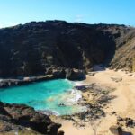
This is the portion that balances more “green” and coastal nature sights. The route includes Waialae Golf Course and Moanalua Gardens, plus Black Point Sea pools.
From above, golf courses and gardens often read as organized green patches—different textures compared to surrounding development. You may not get the fine detail you’d see from a walk-through, but aerial views are great for spotting the overall shape and how much space these areas take up.
Black Point Sea pools also add a coastal-water element beyond the big harbors and beaches. Again, you’re not hovering long enough for detailed exploration, but the aerial vantage can make the shoreline features easier to spot than when you’re standing on land.
If you like variety—beach, city, and a little more nature—this route gives you that within a short time.
Aloha Stadium: the recognizable finish that helps you remember the loop
Near the end, you’ll see Aloha Stadium on the route. A stadium acts like a visual anchor. It’s a clear landmark that can help you mentally map the flight as one continuous loop rather than a list of unrelated views.
That matters because the total time is short. By the time you’re back near the end of the route, recognizable spots make the flight feel coherent—like you checked the main boxes.
Safety and pilot quality: why the name Stefan gets mentioned
One review specifically called out the experience as professional and safe, with pilot Stefan credited for delivering a first-class flight over Waikiki. Even if you don’t know Stefan personally, that kind of detail tells me the operation prioritizes communication and smooth flying.
Also, because the tour includes headsets and is private, you’re more likely to feel “guided” rather than just “transported.” That’s a big part of why these flights tend to land well for people: you’re paying for both the sky view and the human handling of the experience.
Value check: is this tour worth the cost?
Here’s how I’d judge the $359 price.
You’re paying for:
- a private helicopter format (just your group)
- 30 minutes in the air with a guided route around major landmarks
- practical inclusions: headsets and a cell phone lanyard
- a strong overall rating and recommendation rate
You’re not paying for:
- a long multi-stop excursion
- a long duration of island coverage
So the value is highest if you want a short, high-impact experience and you’re traveling as a couple or small group where private time matters. If you’re flying solo and expecting a budget-friendly outing, it may feel steep compared with ground options. But if you can treat this as a once-in-a-while splurge, the price starts to make sense fast.
Weather and timing: the only real variable you can’t control
The tour requires good weather. That’s not a minor footnote; it’s the key condition that decides whether the flight happens.
The good part is that the experience is offered with a plan for bad weather: if it’s canceled due to poor weather, you’ll be offered a different date or a full refund. You don’t need to gamble blindly. Still, keep in mind that Honolulu’s conditions can change, so a flexible schedule helps you actually enjoy the sky time you’re paying for.
Also, because the flight is only 30 minutes, you’ll want to arrive with your phone ready and your camera plan simple. The air time won’t wait while you figure things out.
Who should book this 30-minute private flight
This tour is a great match if:
- you want the big-picture Honolulu view without spending hours on the ground
- you like a guided flight with a pilot who points out what you’re seeing
- you’re traveling with a group that values privacy over crowds
- you want a memorable splurge that’s short enough to fit into a busy Hawaii plan
It may not be ideal if:
- you hate weather uncertainty and have zero flexibility
- you’re looking for an all-day island tour rather than a focused highlight loop
- you’re sensitive to short time windows and might want more than 30 minutes above the city
Should you book Honolulu Helicopter Tours for this private flight?
Yes, if your goal is a fast, high-impact way to see Honolulu from the air. The combination of private-group setup, 30 minutes of flight time, and helpful inclusions like headsets and a phone lanyard makes this feel built for people who want the experience to run smoothly.
I’d book it if you can handle one simple condition: good weather. If your schedule is flexible and you’re okay paying for a premium aerial highlight view, this is the kind of tour that tends to leave people satisfied because it doesn’t overpromise and it doesn’t waste your time.
If you want, tell me your travel dates and whether you’re going solo, as a couple, or with friends. I can suggest how to plan around the weather window and what kind of photos you’ll get most from this exact route.
FAQ
How long is the helicopter ride?
The tour duration is approximately 30 minutes, with about 30 minutes of flight time.
Is this a private tour?
Yes. It’s a private tour/activity, meaning only your group will participate.
What is the price per person?
The price is $359.00 per person.
Where do we meet for the tour?
The meeting point is 1 Lagoon Dr, Honolulu, HI 96819, USA.
Where does the tour end?
The activity ends back at the meeting point.
What’s included in the tour?
The tour includes a cell phone lanyard and aviation headsets.
Do you provide a mobile ticket?
Yes. The tour uses a mobile ticket.
Is there a weight limit?
Yes. The total weight per passenger is 300 lbs.
What if the weather is poor?
The experience requires good weather. If it’s canceled due to poor weather, you’ll be offered a different date or a full refund.
How far in advance should I book?
On average, this tour is booked 13 days in advance.